


Description
Advanced Capabilities in a Portable Package
- Rugged, purpose-built portable navigator with built-in GPS/GLONASS receiver and 5-inch sunlight-readable screen
- Intuitive, simple touchscreen operation and single power button make getting around the display a cinch
- 3D Vision perspective view shows terrain, obstacles, airport environment, optional traffic, nearest airport and more
- Wireless cockpit connectivity via Connext® streams weather and traffic from compatible devices
- Cut the cord and database prices with Wi-Fi® database downloads and the affordable Garmin Navigation Database
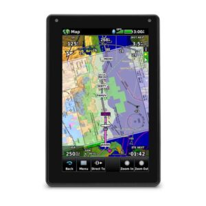
Awareness in Your Hand
The aera 660 aviation portable puts the latest Garmin technology in the palm of your hand, and it carries on our tradition of creating innovative navigators that go way back to the beginning of handheld aviation GPS. While aera 660 is light, compact and fits in any flight bag, it’s also packed with capabilities. As a dedicated navigator, it quickly and reliably acquires GPS and GLONASS satellite constellations and combines advanced navigation tools with rich, interactive, dynamically drawn aviation maps. And it displays it all on a bright, sunlight-readable 5-inch diagonal capacitive touchscreen display. The icons on the aera 660 are instantly familiar to anyone who’s used a Garmin GTN™ touchscreen GPS/NAV/COMM, G5000® integrated flight deck or even the Garmin Pilot™ app, and the intuitive interface allows you to quickly pan across the map screen, pinch to zoom and more. Meanwhile, the power button on the top accesses quick settings, including portrait or landscape orientation, volume and brightness.
Complete Flight Mapping
The aera 660 aviation portable comes preloaded with detailed flight mapping, terrain and obstacles alerting, U.S., European and Canadian SafeTaxi® charts and AOPA Airport Directory or optional AC-U-KWIK global airport directory to put a wealth of resources right at your fingertips — including local fuel prices (U.S. only). The graphical Terrain page offers both overhead and vertical profile views of the topography beneath you. Switch to IFR map mode to display and navigate on high or low enroute airways, and use your touchscreen map cursor to reference MEAs (Minimum Enroute Altitudes) and distances between intersections. The aera 660 even provides vertical navigation (VNAV) guidance to simplify en-route transitions. You’ll stay aware of special airspace activity with more than 650 parachute drop zone details (U.S. only) and get 1-touch airspace information. Garmin Smart Airspace™ guidance conveniently highlights the airspace nearest your current altitude and de-emphasizes non-pertinent airspace so you can quickly identify your location relative to the airspace around you. And, of course, the aera 660 includes our signature direct-to and nearest-airport navigation.
Connect With Your Panel
With an optional power/data cable (sold separately), the aera 660 connects with your Garmin avionics to accept flight plans from your GTN 750/650 navigators, as well as upload frequencies to the standby position of your GTR 200 Comm radio, GTR 225 Comm radio or GNC 255 NAV/COMM radio. It also provides your Garmin NAV/COMM radios with the GPS position source required to look up nearest frequencies.
Weather and Traffic Without Wires
Using Bluetooth® connectivity via Garmin Connext technology, the aera 660 easily interfaces with compatible devices to cut the clutter in your cockpit and improve your flying experience. With a Garmin GDL® 52 portable ADS-B/SiriusXM® receiver or GTX 345 all-in-one ADS-B transponder, you can access and display ADS-B subscription-free weather¹ and advanced traffic alerts, including TargetTrendTM relative motion tracking and TerminalTrafficTM, so you’re aware of potential conflicts in busy terminal airspace. It even allows wireless control of Garmin VIRB® action cameras to start and stop recording and capture photos.

Reviews
There are no reviews yet.